No! :silly:
Scientists using a combination of satellite imagery, airborne-laser technology, and ground-based plot surveys to create three-dimensional high resolution carbon maps of the Amazon rainforest have documented a surge in emissions from deforestation and selective logging following the paving of the Trans-Oceanic Highway in Peru.
The study, published this week in the early edition of the Proceedings of the National Academy of Sciences, reveals that selective logging and other forms of forest degradation in Peru account for nearly a third of emissions compared to deforestation alone. The findings, which demonstrate the feasibility of using LiDAR and satellite imagery over large areas of tropical forest, have important implications for monitoring, reporting, and verifying emissions reductions under proposed Reduced Emissions from Deforestation and Degradation (REDD) programs, which could compensate developing countries for protecting and sustainability managing their forests.
EDIT
The work shows that some 4.5 million metric tons of aboveground carbon were committed to the atmosphere due to deforestation and forest degradation from 1999 to 2009. Degradation emissions averaged 47% of deforestation emissions over the period, but were offset by forest regrowth, which accounted for 812 million tons of carbon sequestration. Net emissions over the period were thus 3.7 million tons, or roughly the annual emissions of the country of Jamaica. The research reveals a spike in emissions from deforestation and forest degradation in the Peruvian Amazon in 2009. The increase appears to be associated with the paving of the Trans-Oceanic Highway, which connects the Amazon to Pacific coast ports, facilitating the transport of soy, timber, cattle, and other commodities. The project, which has been partially funded by China, has led to a proliferation in logging, clearing for agriculture, gold mining, and exploration for oil and gas in southeastern Peru. Environmentalists fear the highway will exacerbate forest exploitation in a region where trees lock up massive amounts carbon.

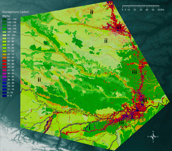
Variation in aboveground carbon storage at 0.1 ha resolution throughout a 4.3 million ha region of the Peruvian Amazon, derived from an integrated use of CLASlite, LiDAR and field-plot data. Examples of (i) artisanal gold mining, (ii) selective logging and other forest disturbances, and (iii) deforestation for cattle ranching, road building, and other infrastructure are indicated. Click image to enlarge.
"We found that the total regional forest carbon storage was about 395 million metric tons and emissions reached about 630,000 metric tons per year," Asner said in a statement, adding that the analysis shows current estimates of carbon stored in the vegetation of the Peruvian Amazon are too high by about a third. These estimates are used as a baseline by the Intergovernmental Panel on Climate Change (IPCC) for determining emissions reductions under the proposed REDD mechanism.
EDIT
http://news.mongabay.com/2010/0906-carbon_mapping_peru.html