If you're an oil man, taking a look under the surface of ANWR, means looking at drilling reports and seismic reports. Inspite of the quality results from seismic studies, nothing beats drilling samples brought up from the rock you suspect bears oil. A 3-D seismic test, is conducted by vehicles that "shake" the ground the ground and uses thousands of geophones to read sound waves below, can create a sort of stereo seismic computerized image, of the oil-bearing strata under the surface. This technique is responsible for reducing the number of dry wells.
But Seismic test vehicles used by the US Geologic Survey have left long straight scars
across the tundra.
So just what do the oil companies know about ANWR ?
Only one well has ever been drilled in ANWRKIC was drilled in 1985, by the Kaktovik Indians, near the coast of ANWR. Kaktovik Indians
drilling report is proprietary, a secret. The Kaktovik Inupiat Corporation (KIC) then shut the well down &
capped the well.
This is ANWR:
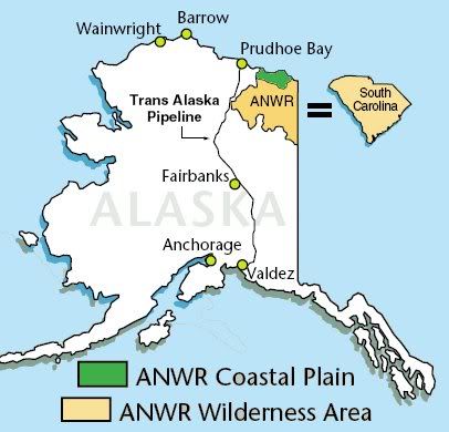
Taking a closer look:

To the west of this map is the National Petroleum Reserve-Alaska. The little red marked box is an area thought to be an extension of the Pt Thompson reservoir. The 2 big oil fields on Alaskas North Slope are Kuparuk is the 2nd largest oil field in the United States at
20 miles by 15. Prudhoe Bay is the largest at
19 miles by 40 miles.
ANWR's Geology and Potential Petroleum Resources.Parts of Alaska's North Slope (ANS) coastal plain have proved abundant in oil reserves, and its geology holds further promise. The oil-bearing strata extend eastward from structures in the NPRA, to the 2 billion barrel Kuparuk River field, past the Prudhoe Bay field (originally 11-13 billion barrels, now down to about 4 billion barrels),
and a few smaller fields, and <strong>may continue through ANWR's</strong> 1002 area. Further east in Canada's Mackenzie River delta, once promising structures have not produced significant amounts of oil.
Source.
So there is Prudhoe Bay, the super big oil field, and as you head east you cross the Canadian border and then run into the MacKenzie river. The Canadians have drilled in this area, and as far as I know, no commercial production resulted.
These are 2 good maps

that shows as one moves east, the oil fields get smaller. And here is a composite image on page 3 of this pdf
http://www.dog.dnr.state.ak.us/oil/products/slideshows/stratigraphic/alaska_stratigraphic_test_well.pdfEven the Energy Information Agency uses lots of qualifiers when speaking about ANWR:
ANWR Production UncertaintiesThere is much uncertainty regarding the impact of opening ANWR on U.S. oil production and imports, due to several factors:
There is little direct knowledge regarding the petroleum geology of the ANWR region. .... based largely on ... neighboring State lands. Consequently, there is considerable uncertainty regarding both the size and quality of the oil ... in ANWR. ... ultimate oil recovery and potential yearly production are highly uncertain.
Oil field sizes.
The size of the oil fields found in ANWR is one factor....if the reservoirs are smaller than expected, then production would be less.
The quality of the oil and the characteristics of the oil reservoirs. Oil field production rates are also determined by the quality of oil found, e.g., viscosity and paraffin content, and the field�s reservoir characteristics, i.e., its depth, permeability, faulting, and water saturation.
Ok, ya'll following things so far ? Heres the kicker:
This analysis assumes oil quality and reservoir characteristics similar to those associated with the Prudhoe Bay field.
ANWR is not Prudhoe Bay.
The north west corner of ANWR is said to be home to 4 to 11 billion barrels of oil, not a lot of oil in the larger scheme of things. Oil companies hold
68 million acres in leases, estimated to contain 100 billion barrels of oil, enough to nearly double domestic oil production, and increase natural gas production by 75%. Three quarters of those 68 million acres
lie idle. The
Interior Department has estimated 18 billion barrels of oil can be pulled from waters off the U.S. coast that are currently off limits.
But in existing leases there are 100 billion barrels. SO fuck it, lets drill in ANWR and get those 8 or 9 billion barrels, and ignore all the other oil we know is there.
Further reading:
175 to 500 billion barrels in the Dakotas:
http://www.nextenergynews.com/news1/next-energy-news2.13s.html90 billion barrels north of Arctic Circle
http://www.usgs.gov/newsroom/article.asp?ID=1980&from=rss_homehttp://www.dog.dnr.state.ak.us/oil/products/maps/northslope/images/NS%20Maps%202008/ns_oandg_activitymap_jul08.pdf
