Expected record high heat causes fire warnings
By Jesus Sanchez, Times Staff Writer
11:10 AM PDT, March 12, 2007
Record high heat and low humidity is expected today across much of Southern California, where many inland and mountain areas were placed under a "red flag" warning because of the high potential for brush fires.
The heat today is expected to surpass Sunday's sweltering conditions in many locations as forecasters projected temperatures to soar into the 90s in many areas and to approach or break record highs for the date.
The thermometer in downtown Los Angeles, for example, is expected to peak at 92 degrees, which would surpass the old record of 87 degrees set in 1959, according to the National Weather Service.
Other highs forecast for today include 97 in Riverside, 85 in Lancaster, and 80 in Laguna Beach; all would set records for this date. Temperatures will also remain high in inland Orange County, where firefighters were battling a 2,000-acre blaze in the Anaheim Hills.
http://www.latimes.com/news/local/la-me-heat13mar13,0,7832056.story?coll=la-home-headlinesFolks, we ain't seen nothing yet. If the indications of a La Nina are right the Southwest is in for a hard drought this year, and coming on top of an already hot and dry spring we are going to see massive fires in the west. With firefighters shorthanded because of Iraq.
http://www.noaanews.noaa.gov/stories2006/s2572.htmNOAA SAYS LA NI�A HERE AS PREDICTED
Expect Northwest Storminess and More Drought in South/Southwest
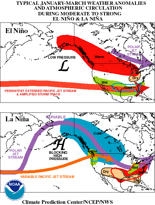
Feb. 2, 2006 � The NOAA Climate Prediction Center announced today the official return of La Ni�a. Agency forecasters predicted La Ni�a was forming nearly three weeks ago. Oceanic sea surface temperatures have met the operational definition of La Ni�a for the November through January period. La Ni�a is the periodic cooling of ocean waters in the east-central equatorial Pacific, which can impact the typical alignment of weather patterns around the globe. NOAA predicts this La Ni�a event will likely remain into late spring, and possibly into summer. (Click NOAA illustration for larger view of La Ni�a conditions across the globe. Please credit �NOAA.�)
"In mid-January the atmosphere over the eastern North Pacific and western U.S. began to exhibit typical La Ni�a characteristics in response to the cooling in the tropical central Pacific Ocean," said Vice Admiral Conrad C. Lautenbacher, undersecretary of commerce for oceans and atmosphere and NOAA administrator. "This pattern will favor continued drought in parts of the South and Southwest from Arizona to Arkansas and Louisiana, and above normal precipitation in the Northwest and the Tennessee Valley area." Periodic precipitation in the drought areas and dryness in the stormy areas also are typical within the larger scale climate pattern described above.
Internationally, La Ni�a impacts during the Northern Hemisphere winter typically include enhanced rainfall across Indonesia and northern Australia, as well as in the Amazon Basin and in southeastern Africa and below-average rainfall across the eastern half of the equatorial Pacific and eastern equatorial Africa.
Typically, La Ni�a events favor increased Atlantic hurricane activity, however, Jim Laver, director of the NOAA Climate Prediction Center says, "It is too early to say with confidence what effects this La Ni�a event will have on the 2006 hurricane season."

